
La Via Domitia à St Rémy de Provence
Sport, Pedestrian sports, Hiking itinerary
in Saint-Rémy-de-Provence
9.1
km
-
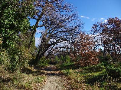
Discover France's oldest road, the Gallo-Roman route through Saint-Rémy-de-Provence (the cité de Glanum). A beautiful 9.5km suburban itinerary, with no major changes in altitude, starting from the tourist office.
-
The route follows part of France's oldest road, Via Domitia, and the Compostelle GR653D, crosses the Canal des Alpinnes, and passes the boards dedicated to Vincent Van Gogh... And if time permits, take a trip to the Antiques Museum, the Glanum town and the Cabestan at the St Paul quarry. Nature-wise, St Rémy-de-Provence lies at the heart of the Parc Naturel Régional des Alpilles, so the area's landscape heritage is a major asset: olive groves, vineyards, hills and mountains. These are all...
The route follows part of France's oldest road, Via Domitia, and the Compostelle GR653D, crosses the Canal des Alpinnes, and passes the boards dedicated to Vincent Van Gogh... And if time permits, take a trip to the Antiques Museum, the Glanum town and the Cabestan at the St Paul quarry. Nature-wise, St Rémy-de-Provence lies at the heart of the Parc Naturel Régional des Alpilles, so the area's landscape heritage is a major asset: olive groves, vineyards, hills and mountains. These are all assets for the flora and fauna, and it's not uncommon to come across Bonelli's eagle, "the regional treasure", the Circaète Jean Leblanc and the Percnopter vulture soaring overhead. Not far away, the Plateau de la Caume reserve is home to most of these species.
Information panels are available along the route.
- Departure
- Saint-Rémy-de-Provence
-
-
Difference in height
- 113 m
-
-
-
Plain text period
- All year round.
-
-
-
Documentation
- GPX / KML files allow you to export the trail of your hike to your GPS (or other navigation tool)
-
- See all reviews
- 113 meters of difference in height
-
- Maximum altitude : 119 m
- Minimum altitude : 69 m
- Total positive elevation : 113 m
- Total negative elevation : -116 m
- Max positive elevation : 45 m
- Min positive elevation : -40 m
